
North Sweden
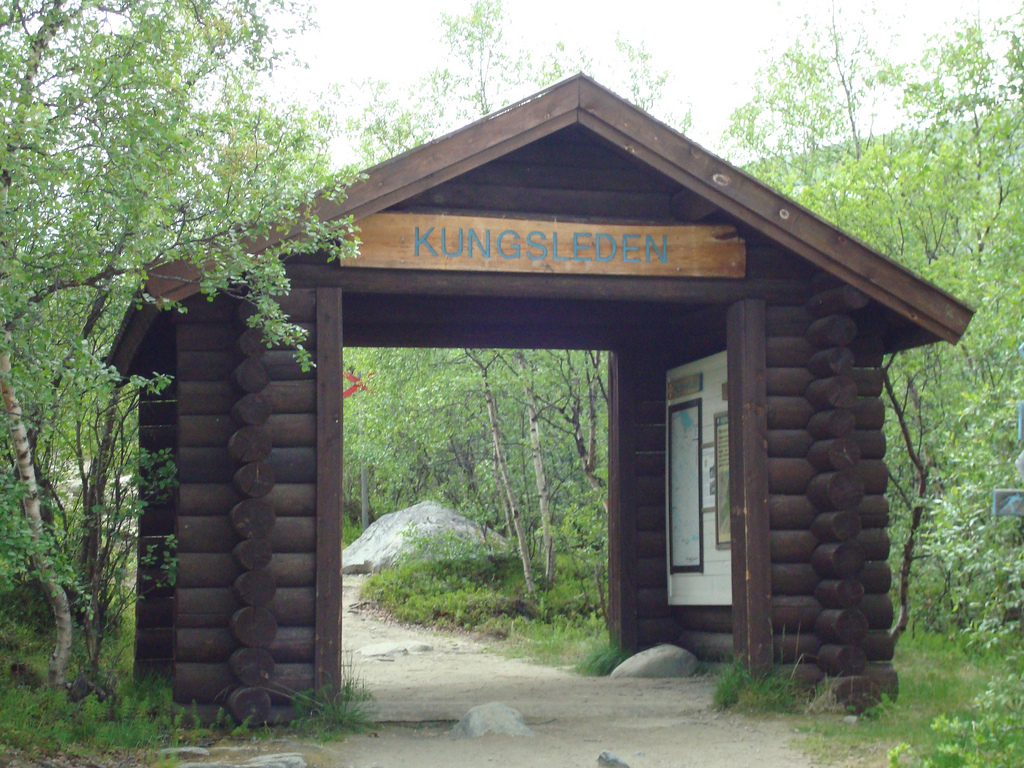
As some of you may know, I’m an avid long-distance hiker. I started hiking in 2015, when I did the West Highland Way in Scotland and I’ve been going on long-distance hikes at least once a year ever since. In the summer of 2017 I took the 17-hour train ride from Stockholm to Abisko, to hike 216 kilometers in 8 days along the Kungsleden, which is Swedish for the King’s Way.
My Journey into the Arctic
My train departed from Stockholm in the late afternoon and I was to arrive in Abisko around 11am the next morning. As I left the city and even though I was slightly hungover because I went on a pub crawl in Stockholm the night before, I felt energised and excited; I was going further up North than I’d ever been before. Hell, I was going to the Arctic Circle, which sounded so cool that I couldn’t wait to arrive in Abisko and smell the fresh Arctic air. As cities began to make way for beautiful Swedish nature and the sun started to set, I fell asleep on the train.
The next morning I woke up to grey clouds and patches of snow everywhere I could see. I started to feel a bit nervous; am I really prepared for this? Luckily, it wasn’t cold, it’s just that the snow in the Arctic Circle never really seems to melt. At every train stop hikers got off and on the train and after a couple of hours, I finally arrived in Abisko. I already had everything I needed in my backpack, so I started looking for the start of the trail right away.
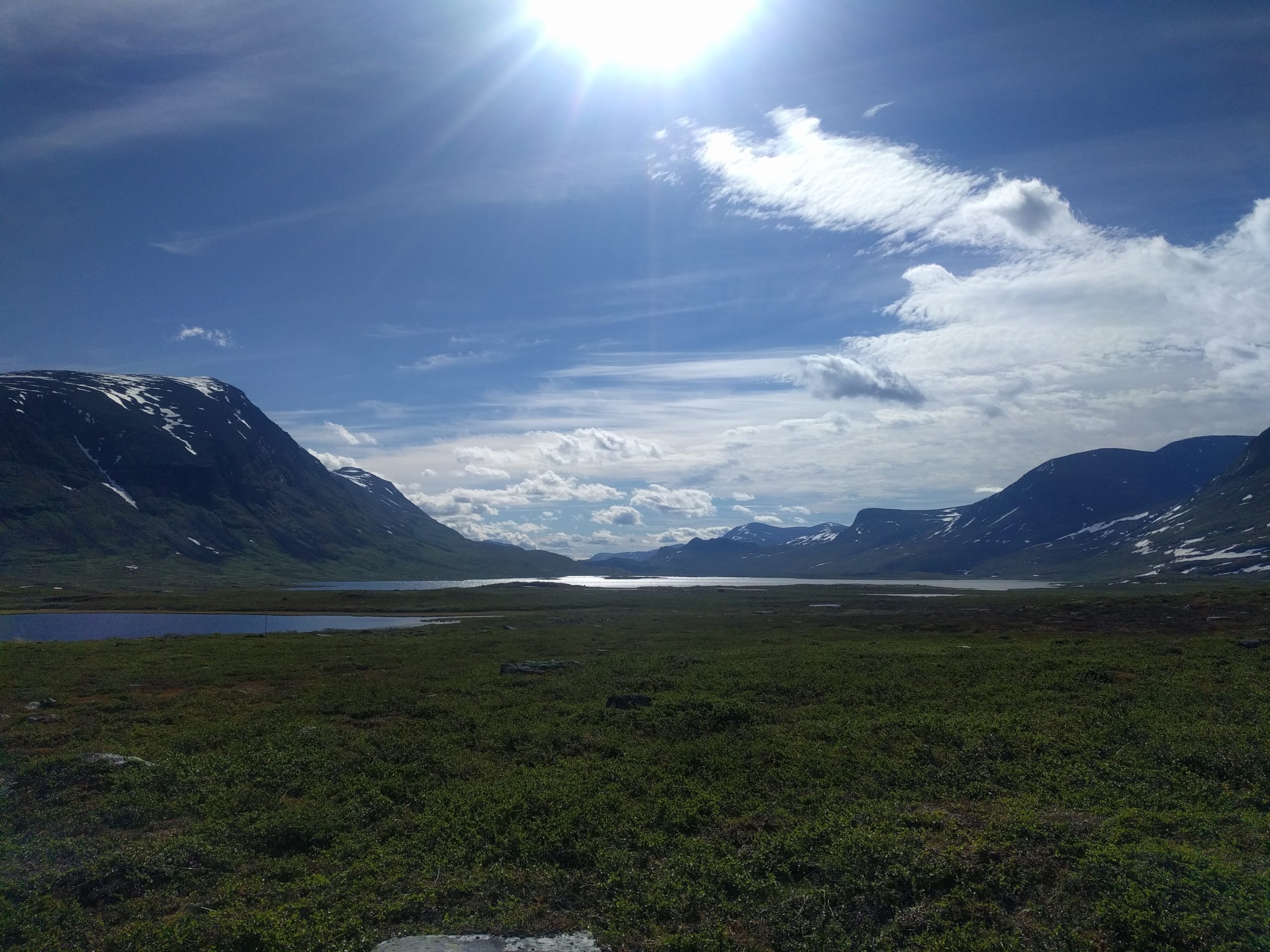
The trail starts next to a rough river, which has dug itself into the stone underneath, making it a spectacular shallow canyon. The water in the rivers and lakes in Northern parts of Sweden is drinkable, which is ideal when hiking because it saves you having to carry around a lot of water. As I was hiking the first couple of kilometers, the grey clouds started to make way for an arctic blue sky. I unzipped my zip-off pants so I could hike in shorts. After another couple of kilometers I deeply regretted that decision; there were mosquitos everywhere! And when I’m hiking I stop to make small talk with everyone, which meant that I gave the mosquitos enough time to dig there nasty angles into my calves, leaving roughly 30 itchy bumps on my poor poor legs.
Coming back to me making small talk with everyone; I like to believe that I’m being the nicest version of myself while I’m hiking. Being out in nature has that effect on me. I could never be that nice in the city, where everyone, including me, seems to always be in a rush, cycling from A to B as quick as possible. And it’s always loud and there are so many distractions. When I’m hiking though, I’m in the midst of nature and while meeting likeminded people, I don’t feel distracted or rushed. I feel calm, friendly, happy and excited. And I feel free; everything I need for at least a week is in my backpack: food, clothes, a ‘house’ (tent), a ‘bed’ (sleeping mat and sleeping bag) and a good book. And there’s no reception so no mindless looking at a screen (although I do like to listen to some music from time to time).
After some 20 kilometers, I found a nice wild camping spot next to a waterfall, where I pitched my tent. The camping spot was packed with mosquitos, so every two seconds I had to frantically slap all the mosquitos of my face. One of those little bastards got to me though, as I found out the next morning as my eyelid was completely swollen, reducing that eye’s vision to max 20 percent. Also, I looked like Harry Potter in the seventh movie, when Hermoine transforms Harry’s face into an ugly mess so that Voldemort’s goons wouldn’t recognize him. I made a mental note to myself: next time bring one of those extremely dorky mosquito hats, it’s worth it.
After a calm comes a storm
The next day was amazing. I woke up to blue skies and a bright yellow sun. I had a breakfast shake (a powder that contains 33% of all the vitamins and minerals mixed with water), packed my tent and went on my way. My legs were a little sore from the first day, but after a couple of kilometers I felt perfectly fine again. The scenery was amazing, mountains with patches of snow, clear lakes and beautiful green fields of grass. In the distance I could see Sami settlements. The Sami are the native inhabitants of the northern parts of Scandinavia and the west-northern parts of Russia. Their settlements consist of tipi-like tents that they set up during summer so they can let their kettle roam freely on the arctic plains. I ran into a girl I met the day before, with whom I eventually ended up hiking the rest of Kungsleden.
As perfect as the weather was at the start of the day; as bad it became near the end of it. Sometime during the later afternoon, grey clouds started to appear and it started drizzling. The path became a bit tougher, as more and more patches of snow had to be crossed along the way. At this point, I was hiking together with my new friend and we pushed each other to continue hiking; it’s really shitty to pitch your tent in the rain so you might as well continue hiking until, fingers crossed, the weather clears up. But that didn’t happen; instead it started pouring and we quickly started to feel colder and colder. Pro hiking tip: always stay warm. Your body has to use a lot of energy to keep it warm, so you’d better use proper clothing to stay warm so your body can use the energy for the hike. We took a quick break to drink some tea to warm up, before we started hiking up this mountain:
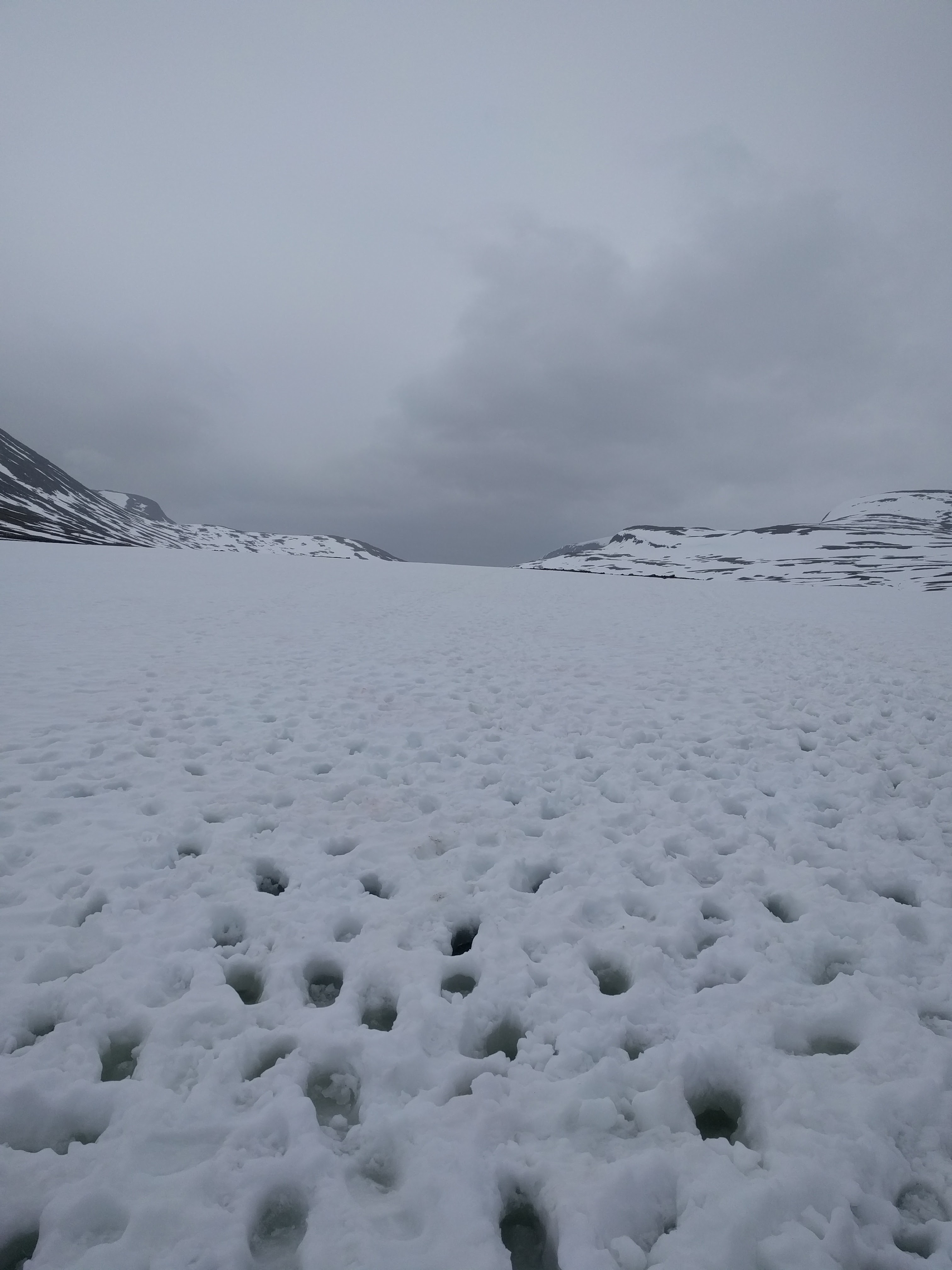
It was the toughest climbs I ever had to do. There basically was no way back; there were no camping spots back the way we came from and we certainly couldn’t have pitched our tents in the snow. We had been hiking for 30 kilometers, it was starting to get dark and we were cold and wet. Every time we took a step, we would step through the snow into the wetness underneath, causing our shoes and socks to be soaked. There was a lot of water underneath the snow, so small stream had formed, which weren’t visible due to the snow on top. A miss step meant tipping over into the snow, causing more wetness and coldness. I’ve been in dire situations during a hike before, were you feel trapped because you can only go forward and going forward means putting in some really hard work and really pushing your limits. The only thing we could do was to focus on the horizon, because we knew that there would be an emergency shelter at the top.
After what felt like forever, we finally arrived at the emergency shelter. We made it! I still sometimes think of that emergency shelter, visible down the mountain as I was ploughing through the snow. Every time I feel stuck I picture that emergency shelter on top of that mountain and I know that you always have to push through because you will eventually reach that thing on the hill and I will be rewarding AF.
In the shelter, we were able to dry our stuff, make some (warm!) food and warm up in our sleeping bags. What a day!
Canoes!
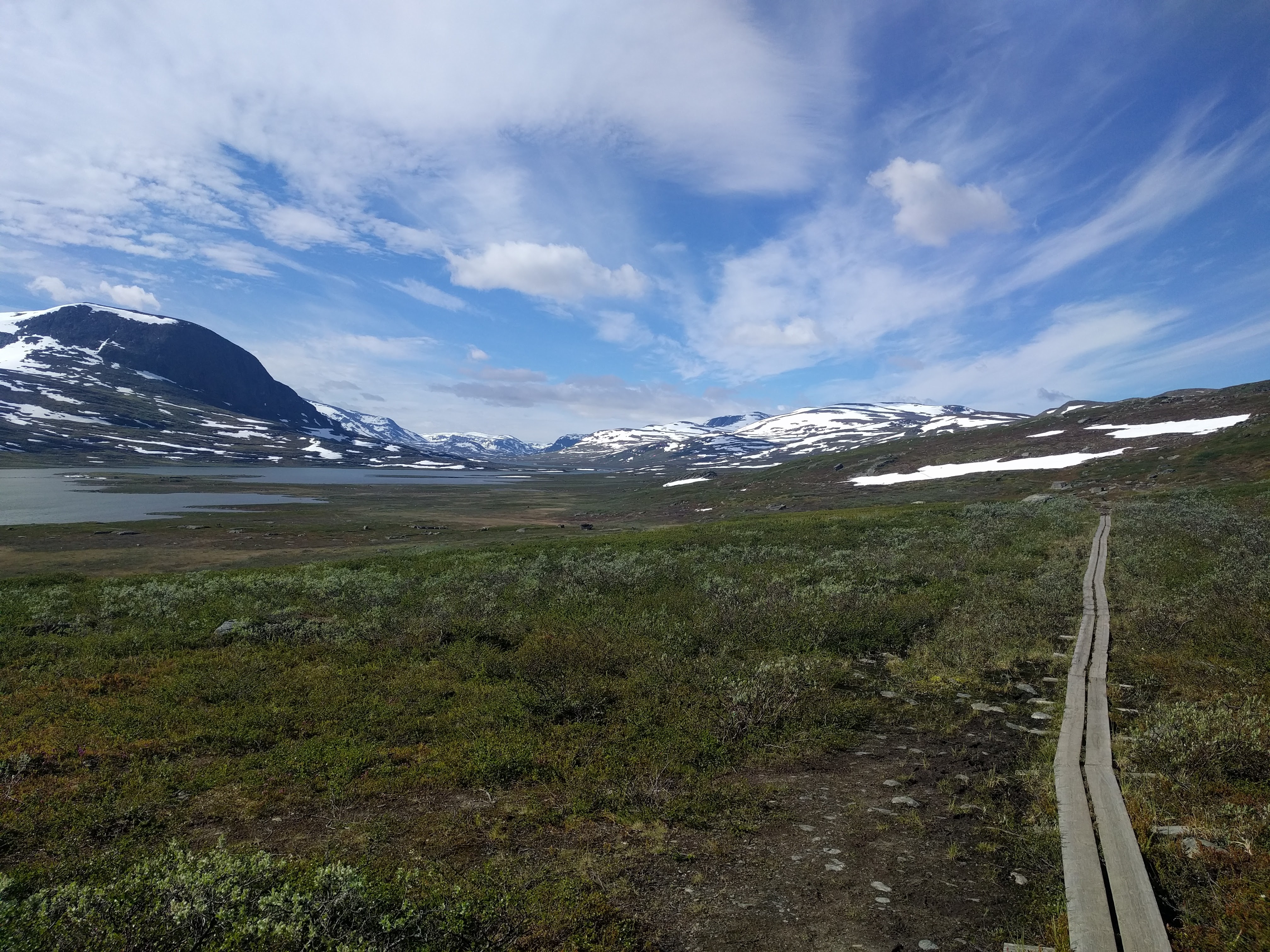
The hike from Abisko to Tjäktja continuously ascends until the highest point along this part of Kungsleden, which is the emergency shelter. From there on, it’s a descend until you arrive in Singi, which is what I did a day later. Another beautiful day, with the sun and rainly clouds battling for attention throughout the day. I saw some more Sami settlement, and I crossed a couple of Swedish huts, which are available to stay in along the Kungsleden. These huts can be booked, so it is possible to hike Kungsleden without having to bring a tent. Being the Bear Grylls wannabe that I am however, I of course didn’t stay in the huts but camped every night. The huts are very convenient though, as some of them have little stores or a public lounge room and drying rooms, which was very welcome given the wet adventure I had the day before. That night, I camped near a river and I fall asleep to the comforting sounds of a light rain on my tent.
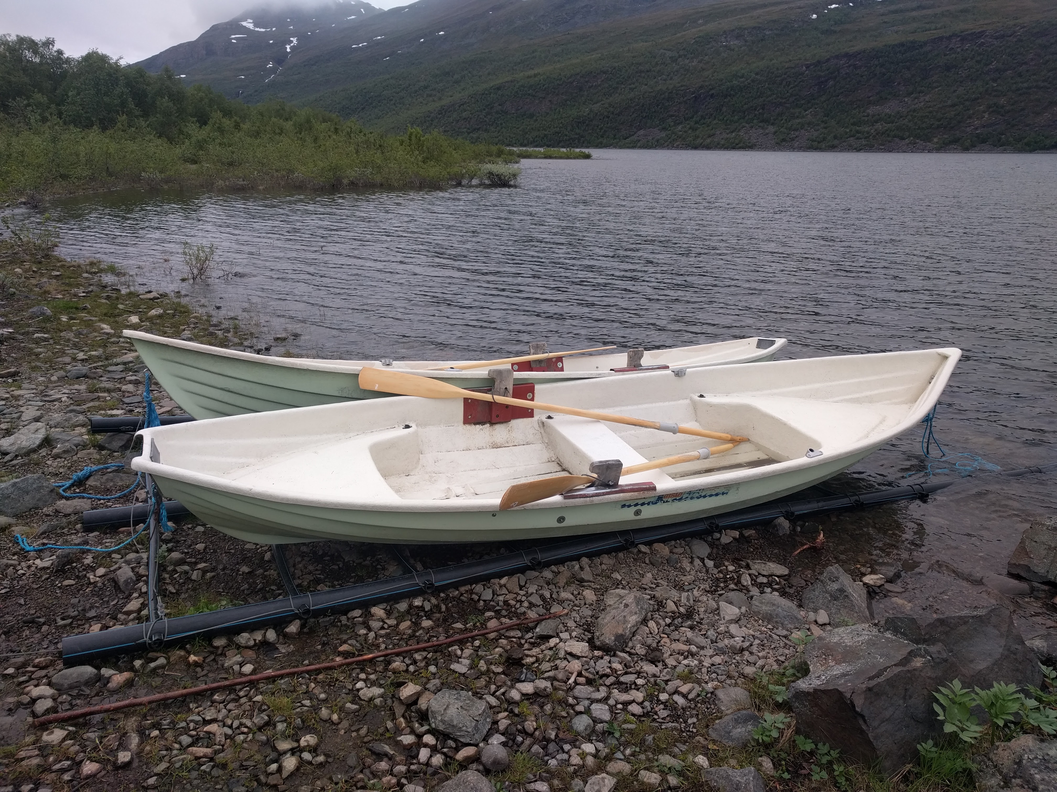
The next day brought along another highlight of my hike on the Kungsleden: canoes! Near the end of the day, near a town (a couple of houses) called Teusajaure, I had to cross a river with a canoe! So the deal with these canoes is that there’s three in total. If you’re lucky, there’s two canoes on your side of the river and one on the other side, so you can just cross the river and be done with it. If there’s one canoe on your side however, you have to cross the river, attach one of the two canoes at the other side to yours, row back to where you came from and drop one canoe off there, and cross the river again, totalling to crossing the river three times. This way, there’s always at least one canoe on either side, so everyone’s able to cross the river by canoe.
My excitement was quickly crushed though, as one of the towns people recommended us to be brought over by speed boat, as it was very windy and the river’s current was quite strong. Plus, it was starting to get dark and since there was only one canoe on our side of the river, we had to canoe back and forth three times. So we, my friend from the other day and I, decided it was wiser to go by speedboat instead. Luckily, we would be given another change to cross a river by canoe two days later.
We find a nice wild camping spot up the hill near the river and I fell asleep once more to the soothing sounds of a light rain agains my tent.
Back in civilisation (briefly)!
The last part of the most Northern part of Kungsleden crossed a flat plane between Teusajare and Vakkotavare. Albeit not as big of a challenge as the snowy ascend to the Tjäktja emergency station from three days before, it was still a shitty, wet and stormy way before we eventually arrived in Vakkotavare. Even though the distance between these two places is only 16 kilometer, it still took us almost five hours before we arrived in Vakkotavare. This was due to the ‘path’ being mostly underwater, as it’s positioned next to a lake that was completely flooded due to the rainfall of the previous days. So even though the path consisted mostly of board walks, it was a very challenging hike since wet board walks are quite slippy and you definitely do not want to fall into a flooded lake due to reasons that should be quite obvious.
And whenever the path was completely under water, it was not existing at all. The flat plane consisted mostly of flooded grass lands or rocks, meaning you either had to march through water or climb over rocks. More than once I was afraid I would slip off a rock and hurt myself badly. And trust me, you really don’t want that in the middle of nowhere with no form of shelter near and in the pouring rain. And I was freaking cold as well. But again, the only thing there is to do is to go forward. After slipping and sliding, climbing and hiking we finally arrived at the shelter in Vakkotavare, which was packed with wet faces. But there was a nice and warm fire, which was every so rewarding after a shitty day of hiking. And, we were back in civilisation! There was a proper road with a bus stop and I finally had reception again after 5 days of being of the grid. I quickly replied to my worried parents (Mom; I told you that I wouldn’t have reception!) that I was indeed still alive and kicking and that the hike was not dangerous at all and that I hadn’t been scared that I would freeze or fall and hurt myself whatsoever.
I took the bus and boat from Vakkotavare to Saltoluokta, to arrive at a beautiful hotel/lodge/campsite area where I actually booked a room in one of the lodges, to re-energise. And I had a proper Swedish diner, which was very much welcome after all the instant food I had the past five days. In the lodge, I started chatting with a Swedish man, who eventually would inspire me to visit the Lofoten in Norway a couple of days later. I’ll write a blog about that some other time.
The next day, I woke up energised and excited for the last 3 days along Kungsleden to Kvikkjokk.
Beer & Fish
Day 6 was stunning; an easy hike and a beautiful sunny day. After hiking 20 kilometer to Sitojaure, I arrived at the ‘boat stop’ where you have to cross a river by boat, which goes up and down the river twice a day. The boat driver lives right at the water with his family throughout most of summer, to take hikers up and down the river a couple of times per day. And he was selling beer and freshly caught, smoked fish. Well, anyone that knows me knows that I’m alway down for a beer after a day of hard work, so I decided to buy a beer and a fish, as did my friend.
We hiked some more after arriving at the other side of the river, which was a 15 minute boat ride. We ate the fish and drank the beer at a beautiful hill side as the sun was starting to set.
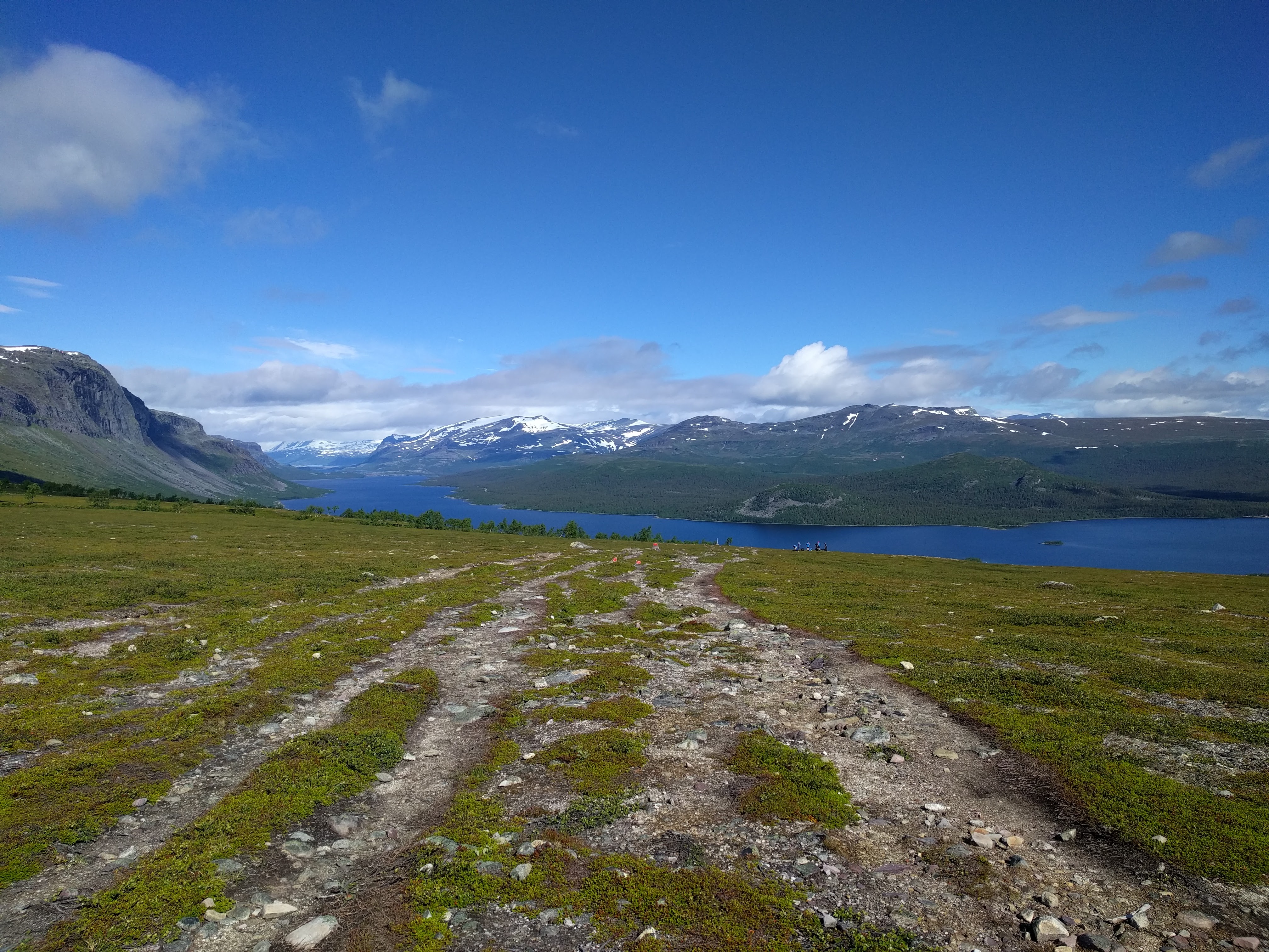
We continued hiking up a hill, where we saw a beautiful hill top that seemed to have an amazing view of the canyon towards which we were walking. We dropped our bags and walked up this hill and indeed, the view was absolutely amazing. A beautiful valley with a huge lake in the middle, mountains on every side and green forests surrounding all of it. There’s pictures, but they just do not justify the sheer beauty that view had. We hiked back down the hill, picked up our bags and found a wild camping spot with lake view and extra mosquitos near Aktse, which is the second lake you have to cross by canoe!
So the next day, we had to canoe to the other side of the lake, but there was only one canoe on our side (remember that canoe logic from before?). Woops! The lake was quite big, so we weren’t really feeling canoeing back and forth three times. But, then something amazing happened; someone was canoeing our way from the other side of the lake! That meant that there would be a canoe on our side even if we would take the one that was already on our side. Winning!
We calmly paddled across the lake, which was really cool. And remember that amazing view I was describing before? Well, we were now canoeing in it!
216 Kilometers: Done & Dusted
We arrived at the other side of the lake and spend the next two days hiking from Aktse through Pårte to Kvikkjokk, which was the end of the Kungsleden for me (even though Kungsleden continues for another 250 kilometers to the South). The last part was characterised by forests, lakes and less mountainous terrain, but ever so stunning. We camped at the campsite near Pårte, which again was packed with mosquitoes and we hiked the last part to Kvikkjokk on the eight day. In Kvikkjokk, I said goodbye to my friend and continued my journey towards the Lofoten in Norway, during which I had to spend a night at a desolated train station, spend a lot of money on one beer and woke up with an amazing seaside view from my tent. But more on that later.
Main takeaways
- The most Northern part of Sweden is one of my most favourite places in Europe
- Pushing your limits and extending your comfort zone is one of the most rewarding things in life
- Hiking, in general, gives you a sense of clarity that you wouldn’t get in the city
- It’s very special to spend 7 days straight, 24/7, with someone that you didn’t know before.
- Mosquitoes have the special ability to turn your face into a messed up Harry Potter